 NERC Data Catalogue Service
Gocad .ts files
Type of resources
Topics
Keywords
Contact for the resource
Provided by
Years
Formats
Representation types
Update frequencies
-
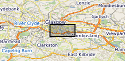
The UK Geoenergy Observatories (UKGEOS) Glasgow 3D coal mine model outputs, created by the British Geological Survey, provide a semi-regional overview of the depth and extent of surveyed and probable coal mine workings, plus stone and coal roads surveyed within the mines. The model allows users to visualise the surveyed and probable coal mine workings to be found beneath this part of Glasgow, applicable at a scale of around 1: 25,000 to 1: 10,000. The data is supplied as grids, triangulated surfaces over a 5 by 4.15 km area, with the depth range to around 300 m below Ordnance Datum. The mine extents are ‘cut out’ of the UKGEOS Glasgow post-drill bedrock model. This model describes both surveyed (recorded on mine abandonment plan) and probable coal mine workings. An area of probable workings has been updated to account for the results of drilling borehole GGC01. Further details and model limitations can be found in the accompanying metadata report http://nora.nerc.ac.uk/id/eprint/531157/
-

The UK Geoenergy Observatories (UKGEOS) Glasgow bedrock model outputs, created by the British Geological Survey, provide a semi-regional overview of the depth and extent of bedrock lithostratigraphic units, coals and faults. The model allows users to visualise the likely subsurface sequence to be found beneath this part of Glasgow, applicable at a scale of around 1: 25,000 to 1: 10,000. The data is supplied as grids, triangulated surfaces and shapefiles over a 5 by 4.15 km area, with the depth range to around 350 m below Ordnance Datum. This model describes an interpretation of the bedrock geology after the UKGEOS Glasgow boreholes had been drilled, the results of the nine UKGEOS boreholes that penetrated bedrock have been incorporated. Further details and model limitations can be found in the accompanying metadata report http://nora.nerc.ac.uk/id/eprint/531157/